When people hear the word drone most look to the sky with fear and trepidation. Are they the next target for a missile strike? Are the police watching them? Is what they do in their back yard going to show up on the web? Rand Paul spoke for half a day about the evils of drones and the press has played on the fear. Rarely do you hear nice things about drones, yet they can be used for good – and we plan to prove it.
How do you change the public perception? Some have suggested changing the name from Drone to something else. The Federal Aviation Administration (FAA) calls them Unmanned Aircraft Systems or UAS and Small Unmanned Aircraft Systems (sUAS) for the little ones. While friendlier, this name still strikes fear because unmanned means: ‘no pilot on board’.

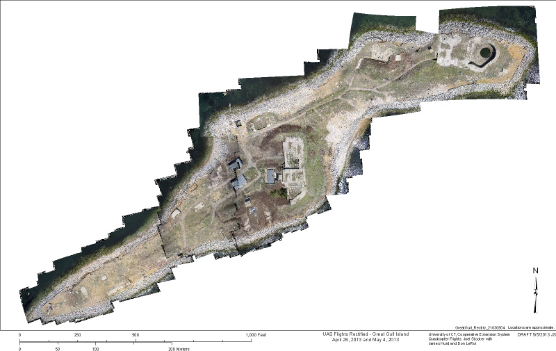
The best way to change perception is to demonstrate what they can do for the common good. To that end, CLEAR, through UConn Extension and Connecticut Sea Grant, is planning a project to map vegetation changes on Great Gull Island in Long Island Sound. Owned and managed by the American Museum of Natural History in New York the island is a nesting site for endangered Terns. Monitoring vegetation patterns will help researchers improve habitat for the birds. The tool to use: A small quadcopter or – DRONE [Boo!].
What’s the difference between a drone and a kids toy? These craft can fly themselves. With an on-board navigation system, GPS, altimeter, and wireless radio transmitter, the operator can set up a flight plan on a computer then let it go on its own. In theory the operator could then sit back with a cup of coffee, however, the FAA requires the pilot be ready to take control at the push of a button. In fact, the UAS has to be visible at all times and an observer has to be present to watch for real aircraft. These details are part of our recently approved Certificate of Authorization (COA), an FAA document required by public agencies.
The UAS we will use weighs less than three pounds and has a camera mounted underneath. A stabilized mount keeps the photographs aligned. Taking a series of overlapping photographs we create a mosaic of features on the ground and then import these into a GIS mapping software. With resolutions in the centimeter range you can count the blades of grass (if you wanted to). Our goal is to head out onto the island before the birds arrive, map the vegetation using the quadcopter, then repeat the process in September after the birds depart. The changes we map will tell us if planned vegetation and invasive controls are working.
Is this for the good? Yes, it’s one small step, and no one’s privacy will be compromised.
The image below is a mosaic of photographs taken from the quadcopter this April and May. Flying at 130 feet the photographs were downloaded, automatically stitched together, then aligned in GIS software.