Smartphones are the swiss army knife of the digital world. They have replaced countless single-function gadgets from calculators to cameras to pagers to, um, phones! But for mapping geeks, one of the gadgets they have not quite been able to shake is the handheld GPS unit, at least until now.
The Geospatial Training Program at UConn CLEAR recently completed a GPS training for land trust volunteers. The training taught participants to collect data (waypoints, notes, tracks) in the field using a GPS unit, download that to a computer, and then create an online map using the collected data that they can share with the public. We teach this course a couple of times a year and it is always well received.
As smart phones have gained in popularity, so has the interest in using them in our class instead of a $200 -$800 handheld GPS unit. After all, most smart phones today include a decent GPS chip that is useful for finding the nearest Starbucks, letting the word know where you are, and tracking your run, ride, or hike. Why not geo-referenced data collection, too?
For years, we have been scouring the app stores for the perfect navigation app that does everything a handheld GPS unit can, and maybe more. Our requirements were that it (1) is easy to use; (2) collects tracks, waypoints, notes, and photos; (3) exports data in a wide variety of geospatial formats; (4) requires minimal processing to create an online map; (5) works on iPhone and Android; and (6) is CHEAP! After many downloads and numerous fits and starts, we believe we have a winner – GPS Kit.
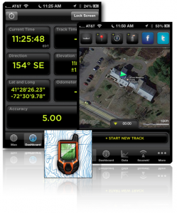
While designed & marketed to “outdoor adventurers,” GPS Kit works great for data collection. As you walk along it tracks your route and displays it on a map; collects data about your speed, distance, elevation, lat. and long., etc.; allows you to mark waypoints (points of interest), take notes, add “weather stations” to get point forecasts, and add pictures to your track. You can alternate between a wide variety of base maps or connect to your own. It also has a built-in compass, flashlight, and how-to videos.
What sets GPS Kit apart from the other GPSish apps we tested is its export/sharing functions. When you have finished a walk/hike around a property and want to share the data you collected, the app neatly packages it all up into a KML, KMZ, or GPX file for sharing via email, facebook, twitter or exporting to your computer via iTunes. This data can then be viewed and edited in Google Earth, Google Maps, or a desktop GIS program. Other apps have similar functionality, but often separate the waypoints, tracks, and pictures, making it more difficult to repackage and view them in a single map.collection. (Note: This works best with a KMZ file and Google Earth/Maps. Other formats & programs may separate the photos out.)
We created a quick map of the Bamforth Preserve in Haddam by walking around the preserve, taking notes and pictures on an iPhone along the way, emailing a KMZ file of the trip from the app, placing that file on our server and then opening and editing slightly it in Google Maps. It took about ½ hour to create (not including the time exploring the Preserve). Much easier and faster than the old handheld GPS method.
View Bamforth Preserve – GPS Class in a larger map
Now that we’ve gotten you all excited, here is the bad news for Android users and penny pinchers: GPS kit is only available for Apple devices and costs $10 for the iPhone version, $15 for the iPad. Also, the app is only as good as the GPS receiver included in your phone. For most purposes this should be fine and on par with recreation grade GPS units. Not perfect, but close!
CLEAR’s Geospatial Training Program plans to unveil a new smartphone GPS training this fall. Stay tuned for details!