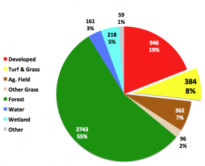
Thanks to Frederick Law Olmsted, Central Park has great expanses of grass. But can you imagine a lawn 14 times the size of Manhattan? That’s basically what we have in the Connecticut and lower New York area. Humble old grass has become the area’s third most extensive land cover, after forest and developed land (see pie chart). It’s also our fastest growing land cover (no pun intended), and the focus of a lot of recent attention by many of the organizations involved with the federal/state Long Island Sound Study.
Our stats on grass come from CLEAR’s Changing Landscape (formerly Connecticut’s Changing Landscape) project, which was updated in the Fall of 2012 (see previous blog) with funding (bless you!) from the aforementioned Long Island Sound Study. The project was expanded not just one but two ways: (1) geographically to include Westchester County, NY and the portions of Long Island draining to Long Island Sound, and; (2) temporally to 2010, creating a unique six-date, 25 year data set of land cover change for the period 1985 to 2010.
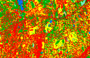
Maintained grasses such as lawns, parks, cemeteries, sports fields and golf courses (see map, below) characterize the turf/grass category. During the 25-year study period, this land cover has been the fastest growing class in relative terms, with about 22% more grass in 2010 than we had in 1985. As of 2006, the acreage of the turf/grass class surpasses the “agricultural field” class, covering approximately 469 square miles, or 8% of the study area. This is about 14 times the size of Manhattan! As one might expect, turf/grass is a constant companion of development; in fact, the two are both included on our “Change to Developed” maps. Together, the two classes form what we’ve come to think of as the “development footprint” of the area.
The implications of the growth of this land cover are encouraging for golfers and landscapers, but implications for water quality are less clear-cut. On the one hand, there is evidence that over-zealous homeowners and others can apply fertilizers and pesticides far exceeding the levels needed for lawn maintenance. This, in combination with the fact that lawns tend to have more compacted soil than other vegetated land covers like forest, creates the potential for polluted runoff. This is of special concern in the Long Island Sound basin, where nitrogen, a fertilizer staple, is a main driver of the problem of hypoxia (low dissolved oxygen). On the positive side, many soil scientists and horticulturalists note that turf grass is very efficient at retaining/using nutrients, and that lawns can – and do—serve as an effective way of absorbing some of the urban stormwater generated by impervious surfaces.
No doubt there is truth to both of these points of view. For both of these reasons, this lowly (pun intended) land cover deserves more attention in the form of research, management and outreach. As stormwater guru Tom Schueler of the Chesapeake Stormwater Network says of that massive watershed (estimated to be about 9.5% grass, see his excellent Technical Bulletin The Clipping Point), the large area devoted to grass “…presents an unrivalled opportunity to apply stewardship practices over this extensive land cover at little or no additional cost.” And if Tom says it’s so, it must be true.