Moving Around the Map

Zoom In and Out
Zoom in and out of the map using the + and - tools located in the upper left corner of the map. Alternatively, use the scroll wheel on your mouse.
To pan around the map, left-click on the map and hold the left mouse button while dragging. The cursor will turn into hand while the pan is active. If you get "lost" on your map and need to go back to the big picture, use the Default View ( ) button in the upper left.
Basemap, Overview Map
 Basemaps
 Basemaps
A Basemap draws below the other layers in a map. To change the basemap, click on the Basemap Gallery icon. Choose from a long list of options. Don't know what to choose? Try the Imagery Hybrid, Topographic, or the Dark or Light Gray Canvas.
TIP! Although not technically listed under the basemap button, any of the Elevation or Imagery layers can be turned on in the Layer List and function as a basemap.
Overview Map
The Overview Map icon is a tiny arrow in the lower right corner of the viewer. Click  to open and show the map and click
  to close it.
Layers and the Layer Panel
Layer List
In the map, the Layer List is open by default on the right side of the viewer when using a large screen device.
Layers are sometimes listed in Groups. Click on the  to open a group. The group needs to be checked in order for layers inside it to be visible
  .
.
Expand as many groups as you like and turn on () any combination of layers. Remember that layers draw in order. Layers higher up on the list will draw above and on top of layers below. Layers often overlap so may cover each other up. If this is the case, use transparency or turn the layer off.
Reorder Layers

The map allows changing the order of layers. Locate the 6-dot reposition ( ) symbol next to a layer. The mouse turns to a cross-hair indicating that clicking and dragging the layer will move it to a different spot on the list. Layers can also be moved outside of their home group and/or into a different group.
Remember that layers draw in order. Layers higher up on the list will draw above and on top of layers below. Layers often overlap so may cover each other up. If this is the case, use transparency or turn the layer off.
Options


Each group item and layer has three-dots on the far right which opens the Options menu. Some layers types have more options than others.
TIP! The Options menu is not accessible (it is grayed out) if the layer is not visible (be sure the layer AND the group are both checked).
-
Transparency
Transparency makes a layer partially or fully see-through.
Search and Find My Location
Location Search

Use the Search Tool (upper left) to find a location, place, address and more. Type into the Search window and press Enter. Search Results will appear below the search box or in the side panel. Click on a result and the map will redraw with the feature centered on the map. Click the in the  to remove the search results.
Find My Location
 Find My Location
The Find my location button adds your current location to the map and zooms to it. The blue dot is your location. Note that the location could be influenced by the internet provider and/or the accuracy of the basemap. It also requires location to be enabled on your device.
Tools: Measure and Scale Bar
Measure
 Measure
Select the Measure icon and then choose to measure distance ( ) or measure area (
 ). Once a measure tool is selected, the mouse turns to an orange circle.
Click on the map to start the measure. Notice that the orange and white line or orange fill is measuring as the mouse moves. Click again to add vertices and continue until the line or shape is complete. Double-click to finish. The measurement is shown on the map and in the Measurement window. The units can be changed at any time.
TIP! While in the middle of measuring, you can makes changes to the measurement units, turning layers on and off, moving the measurement window, and more.
Scale Bar
The scale bar is in the lower left corner of the map. The feature compares a map distance to the actual distance in real life. The number shown is a ratio between the distance on a map and the corresponding distance in the real world. The more zoomed-out the map is, the larger the the number.
Tools: Elevation Profile
Elevation Profile
 Elevation Profile
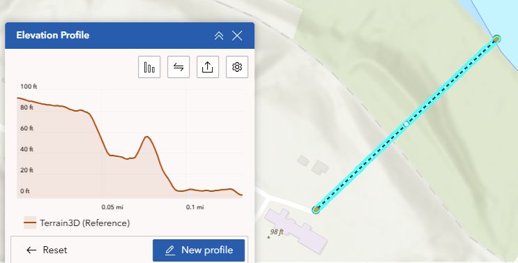
The Elevation Profile tool is useful for visualizing terrain and slope. To use the tool, click the Elevation Profile icon to the left of the map and select Draw.
Moving Around the Map
Zoom In and Out
Zoom in and out of the map using the + and - tools located in the upper left corner of the map. Alternatively, use the scroll wheel on your mouse.
To pan around the map, left-click on the map and hold the left mouse button while dragging. The cursor will turn into hand while the pan is active. If you get "lost" on your map and need to go back to the big picture, use the Default View () button in the upper left.