CLEAR's Geospatial Educators participate in a variety of custom workshops, courses, seminars and training programs at UConn and with outside collaborators. Visit the Schedule & Registration page for dates and details and the Tutorials page for access to our workshop materials and additional training resources.
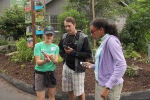
Introduction to GPS Mapping with Avenza Maps
New! This half-day in-person workshop will introduce participants to the free Avenza Maps app on their Apple iOS or Android device. This workshop will focus on how to use the app for data collection. Participants will be introduced to the capabilities and the layout of the app and will learn how to collect GPS data including tracks, placemarks, and geolocated photographs using their device. The workshop will also cover data formats and standardization strategies including the use of data schemas. Additionally, the workshop will touch on uses for GPS data, including contributing to the Connecticut Trail Finder, sharing with others, and strategies for using it in mapping applications including Google Maps, QGIS, and ArcGIS.
Please Note: This is a BYOD (bring your own devices - iPhone or Android AND laptop) training. Loaner laptops will be available by request. Be sure to indicate this in the registration form.
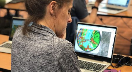
Introduction to ArcGIS Online & StoryMaps
This one-day training introduces students to the basics of creating engaging and interactive maps online using free tools from Esri's ArcGIS Online website. For communities, researchers, and outreach educators, a web map is a powerful tool for soliciting input, sharing information, and engaging stakeholders. This two-part workshop will introduce you to ArcGIS Online in the morning, and story maps, Esri's slick format for sharing maps AND descriptive text and media, in the afternoon.
This workshop is not currently being offered.
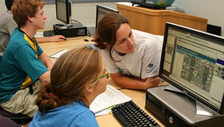
Introduction to ArcGIS Desktop
This intensive three-day course introduces students to basic GIS concepts through the use of ArcGIS10.x software. It covers a wide range of topics and is designed for people with little or no experience with GIS; however, familiarity with PCs, file and folder management, and basic computing chores is required.
This workshop is not currently being offered or redesigned for ArcGIS Pro. See the list of Other Training Programs at the bottom of the page for great GIS training options elsewhere.
Related CLEAR Programs
CLEAR faculty are extensively engaged in the Natural Resources Conservation Academy (NRCA), an innovative program in conservation, land use planning, and geospatial technologies that connects Connecticut high school students, adult volunteers and teachers with conservation efforts at the community level. And with an overlapping but different set of partners, CLEAR faculty are critical to the success of the Environment Corps (E-Corps) initiative at UConn, a program of innovative undergraduate courses that combine classroom instruction, service learning, and Extension outreach. Learn more about these programs below.
Conservation Ambassador Program (CAP)
9-month program for high school students (grades 9-11) interested in exploring the environment or making a difference in their community. The program includes a one-week field experience at UConn and an community environmental action project.
Visit the NRCA website for program dates and additional information
Eco-Digital Storytellers (EDS)
A 6-month program for UConn undergraduate students and high school student-teacher teams that introduces environmental storytelling through interactive maps and digital media, including animation and filmmaking.
Visit the EDS website for program dates and additional information
Environment Corps (E-Corps)
The UConn Environment Corps was created to provide assistance to the communities of Connecticut while providing UConn undergraduates with real work experience and workforce training. Currently there are classes focused on brownfields redevelopment, climate resilience, and stormwater management.
Visit the E-corps website for program dates and additional information
Other Geospatial Training Programs
Be sure to check out additional course offerings from our friends at URI, UNH, and MSU!
University of Rhode Island
The Environmental Data Center at the University of Rhode Island offers short courses in introductory mapping technologies. These include a three day Introduction to ArcGIS Pro workshop and a half-day Using ArcGIS Online training.
Program Contacts: Alyson McCann & Aimee Mandeville
Program Website: https://www.edc.uri.edu/pages/learning-opportunities
University of New Hampshire
The Geospatial Technologies Training Center at the University of New Hampshire provides hands-on, in-person and remote workshops on GIS and GPS topics.
Program Contact: Shane Bradt
Program Website: https://extension.unh.edu/geospatial-technologies-training-center
Mississippi State University
The Geospatial Education and Outreach Project (GEO Project) s a collaborative effort among the Geosystems Research Institute, Northern Gulf Institute (a NOAA Cooperative Institute), and the Mississippi State University Extension Service. The GEO Project provides in-person and online training and technical assistance in the use, application and implementation of geographic information systems (GIS), remote sensing and global positioning systems (GPS) with commercial and "open source" GIS software.
Program Contact: John Cartwright
Program Website: https://www.gri.msstate.edu/GEO/education.php
For citation purposes: University of Connecticut’s Center for Land Use Education and Research. (May 06, 2022). Geospatial Classes. https://clear.uconn.edu/geospatial/workshops.