Desktop GIS Tools
Calculating Impervious Surface Tools
Both of the Tools presented in this section utilize modeling methods of measuring the amount of imperviousness. The modeling methods use numerical or statistical techniques to derive coefficients or equations that are applied to ancillary spatial data, such as land cover and population, to generate impervious surface estimates.
Estimation Tool for Impervious Surfaces
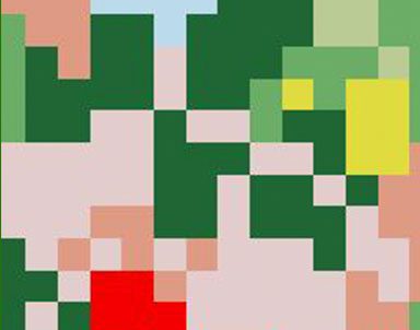
The Estimation Tool for Impervious Surface (ETIS) allows to calculate the amount of imperviousness for specified area based on land cover and population density data. It was developed using linear regression equation and a set of coefficients based on the classes of the land cover map used. There are several sets of coefficients included with the Toolbox for Connecticut Land Cover (CCL) 2002 and National Land Cover Data (NLCD) 2001, but ETIS also allows to import custom sets and to demonstrate the effect of change in land cover on the amount of imperviousness. ETIS can estimate percent impervious cover for future land cover scenarios allowing for comparison to current conditions.
ETIS was developed as an ArcToolbox for ArcGIS 9.2 and ArcView 9.2 using Python Script.
It creates the Output shapefile that has all the Fields and Properties of the Analysis Unit shapefile plus extra "PI" field containing values of estimated imperviousness.
Impervious Surface Analysis Tool
The Impervious Surface Analysis Tool (ISAT) is a GIS extension that estimates impervious surface area using land cover and coefficients. Each land cover dataset requires a specific set of coefficients. Coefficients were developed for use with the Connecticut Land Cover (CCL) 2002 data.
The Impervious Surface Analysis Tool (ISAT), an ArcView 3.x extension, is used to calculate the percentage of impervious surface area of user-selected geographic areas (e.g. watersheds, municipalities, subdivisions).
ISAT was developed as a partnership between NEMO and the National Oceanic and Atmospheric Administration (NOAA) Coastal Services Center, based on a prototype created by NEMO. ISAT can be downloaded free of charge from the Coastal Services Center website.
Landscape Fragmentation Tools
The fragmentation of forests and other natural land covers degrades these resources in terms of both their ecological and economic value. The following tools are used to measure fragmentation in a landscape based on land cover data. Both tools run out of ArcGIS 9.2.
Landscape Fragmentation Tools (LFT) v 2.0
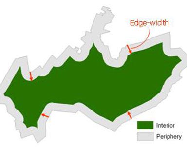
The Landscape Fragmentation Tool v 2.0 is based on a procedure to map forest fragmentation that was developed in a recent study (2007) that included participants from the by the U.S. Forest Service and U.S. EPA. The procedures developed are believed to be more consistent and reliable than previous methods for mapping fragmentation at the landscape level. The tool was developed by CLEAR staff and requires the spatial analyst extension for ArcGIS 9.2.
NOTICE: The Landscape Fragmentation Tool v2.0 (LFT v2.0) was developed based on research by P. Vogt et. al. (2007). Since that time, there has been further development in the procedure by Vogt of the European Commission Joint Research Centre, in the form of the Morphological Spatial Pattern Analysis (MSPA) tool. The MSPA provides a customized sequence of mathematical morphological operators targeted at describing the geometry and connectivity of landscape features of interest. Compared to the LFT v2.0, the final version of MSPA provides more feature classes, and includes the detection of border and core openings.
For more information about MSPA and to download the tool visit:
http://forest.jrc.ec.europa.eu/download/software/guidos/mspa/
Landscape Fragmentation Tools (LFT) v 1.0
The Landscape Fragmentation Tool v 1.0 is based on procedures developed in a study by the U.S. Forest Service (2002). The tool was jointly developed through a partnership between CLEAR and Placeways LLC. This tool requires ArcGIS 9.2
Shape Metrics Tool
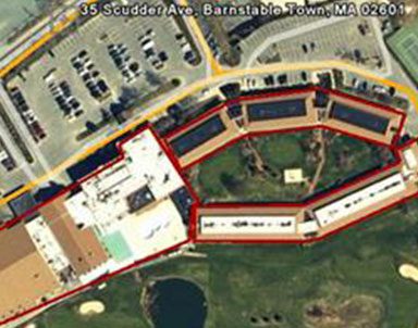
The Shape Metrics tool calculates up to 12 different metrics that measure a particular aspect of a polygon's shape. The tool is run from ArcToolbox and requires the ArcView level of ArcGIS 9.2 or 9.3. No extensions are required.
We are in the process of updating our website, this section will be available at a later date.
KML to SHP Tool
The KML to SHP tool converts the kml files, from Google Earth (version 4.2 or 4.3), to an ESRI shapefile. The shapefile retains the feature names and descriptions. The tool is run from ArcToolbox and requires the ArcView level of ArcGIS 9.2 or 9.3. No extensions are required.
We are in the process of updating our website, this section will be available at a later date.
Urban Landscape Analysis Tool
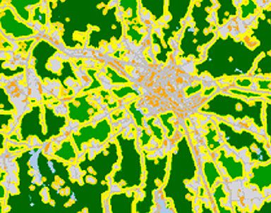
The Urban Landscape Analysis Tool (ULAT) calculates several metrics that quantify the degree of sprawl in a given city for multiple periods in time. The metrics are based on an input land cover image depicting urban land cover, water, and non-urban lands. The tool can be used to analyze change in urban sprawl over time. ULAT runs out of ArcGIS 9.2 and requires spatial analyst.
We are in the process of updating our website, this section will be available at a later date.