Light Detection and Ranging – sounds fancy and highly technical, right? That’s because it is! In a nutshell, Lidar data shows the elevation of the earth’s surface. But the cool parts are what Lidar looks like, shows, and how people are using it. Why am I blogging about Lidar now? Two reasons – the first is recent chatter on our GIS listserve and the second is a new Lidar page on CT ECO. Let’s start with the list serve chatter.
The emails started when a link to a National Geographic article called ”Lost” New England Revealed by High-Tech Archaeology was sent. It explains how several UConn professors are using the highly detailed surface topographic information to identify historic features that cannot be seen through the trees of a forest, such as stone walls. The article refers to the “quiet revolution in archaeology” that Lidar has caused, with archaeologists making new discoveries around the world. The researchers also had a poster at the spring NEARC 2013 GIS conference which includes some cool figures.
This article invited other interesting email contributions. Several were about interesting applications of Lidar including: a solar map and more for New York City, buried historical structures in Glauberg, Gerrmany, or locating the Marylander Burial Ground in Brooklyn, NY.
Other contributions were about what other New England states are doing to collect, use and distribute Lidar data including:
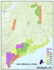
| Maine Office of GIS Lidar for the Northeast |
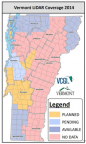
Vermont Center for Geographic Information |
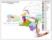
New York State GIS Clearinghouse |
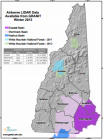
New Hampshire Granit Info and Map |
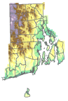
Rhode Island GIS |
Massachusetts GIS |
 |
 |
 |
 |
 |
 |
And two national sources were mentioned. The first is NOAA’s Digital Coast including the Data Access Viewer, the Data Reposiory and the U.S. Interagency Elevation Inventory where you can visualize the data in viewers, bring in a map service, or download the spatial inventory directly. And the second was USGS CLICK (Center for LIDAR Information, Coordination and Knowledge) including Lidar websites and references and the USGS EarthExplorer.
But What About Connecticut?

Connecticut is in the unique situation that eight datasets cover parts of the state and even with eight, not all of Connecticut is covered. The patchwork of datasets is confusing and is now explained in map and detail form on the CT ECO Lidar Help Page. The page includes an interactive map with informational pop–ups and the ability to zoom in to a location and determine which data set or sets, if any, occur there. Also available are links to documents and metadata. Although this raw data is not for the faint of heart (read, meant for GIS professionals), it sheds some light on the Lidar situation in Connecticut. And CT ECO will be hosting some map services of the digital elevation model (DEM) which is the elevation of the earths surface, as well as hill shade, slope and aspect. These will also be available in easy-to-use viewers that are designed for the faint of heart! Stay tuned.
CT ECO
CT ECO is the Connecticut Environmental Conditions Online website which is a partnership between the University of Connecticut CLEAR and the Connecticut Department of Energy and Environmental Protection (DEEP) to share Connecticut’s natural resource geographic information with the public. Visit CT ECO at http://cteco.uconn.edu.
More on What is Lidar?
I like the NOAA National Ocean Service definition: LIDAR, which stands for Light Detection and Ranging, is a remote sensing method that uses light in the form of a pulsed laser to measure ranges (variable distances) to the Earth. These light pulses—combined with other data recorded by the airborne system— generate precise, three-dimensional information about the shape of the Earth and its surface characteristics. And Wikipedia is mighty thorough when it comes to Lidar.
Thanks for reading. Maps are cool.